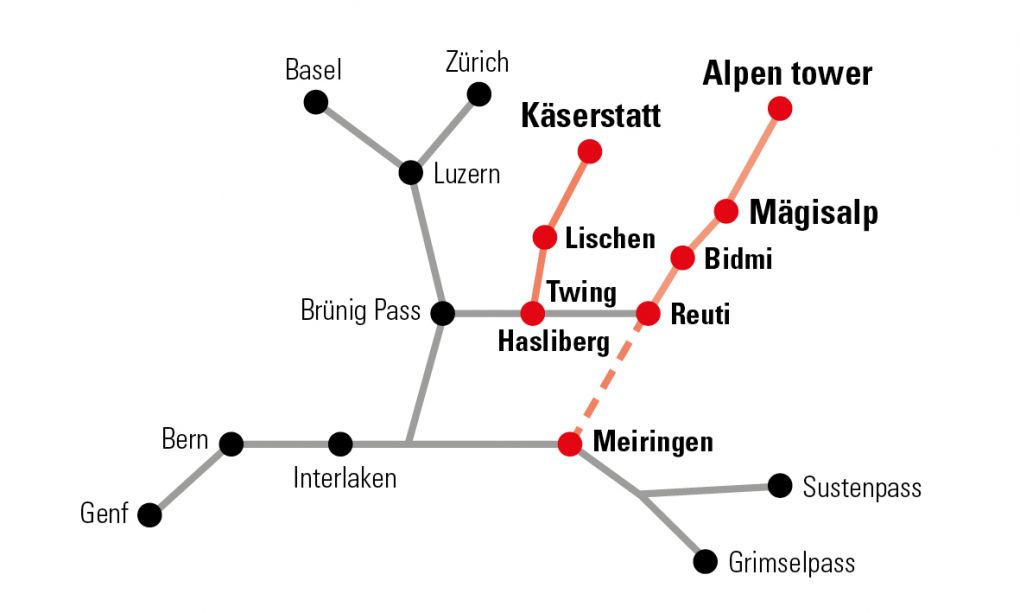
Circular paths Hasliberg
in der schneefreien Zeit im Dorfbereich
Village tour Reuti
Cable car station - Post office - Rufenen playground - Blatti - Steini - Cable car station
Discover traditional and modern architecture and enjoy the magnificent panorama.
Attention: the Steini - Cable car station section may not be accessed from December to mid-April (skiing operation).
Difficulty: medium
Distance: 2 km
Duration: 40 minutes
Ascent/Descent: 110 hm / 110 hm
Start/End: Cable car station or old post office
Trail conditions: Mostly pavement, partly gravel
Special features: Rufenen playground
Mühlefluh circular trail (viewpoint)
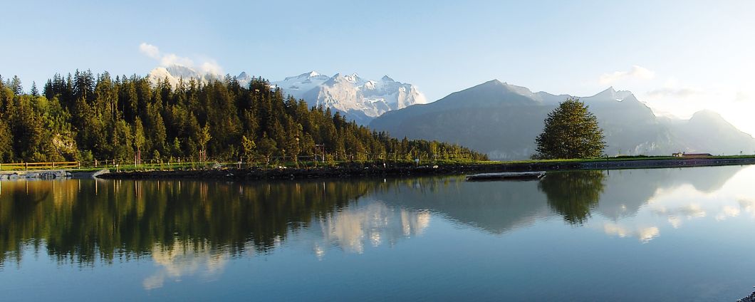
Varied walk through field and forest to Mühlefluh. View of the Engelhörner, Wetterhorn group, Reichenbach Falls, Lake Brienz as well as the Haslital and Meiringen.
Difficulty: easy
Distance: 2.8 km
Duration: 50 minutes
Ascent and descent: 131 hm / 131 hm
Start/end: Old Post Reuti
Trail conditions: Pavement, forest path/nature
Specials: Viewpoint, fireplace Grini, Vita course, Rufenen playground
Difficulty: easy
Distance: 2.8 km
Duration: 50 minutes
Ascent and descent: 131 hm / 131 hm
Start/end: Old Post Reuti
Trail conditions: Pavement, forest path/nature
Specials: Viewpoint, fireplace Grini, Vita course, Rufenen playground
Circular route Eigen
This entertaining hike leads through the fairytale forest "Weidli", crosses the very steep meadowland Eigen, which is very appropriate for mountain farming. After the descent, the hamlet "Wysseflöh" awaits you before returning to the starting point. The circular route in the opposite direction is a bit more strenuous.
Difficulty: medium
Distance: 5 km
Duration: 90 minutes
Ascent / descent: 193 hm / 192 hm
Start / End: Old Post office Reuti
Trail conditions: Pavement, gravel, forest path/ nature
Specials: butterfly path, view to the Engelhörner, into the romantic Urbachtal, on Innertkirchen and the Haslital to Lake Brienz.
Village tour Goldern
Urseni - Mätteli - Eggacher /Hohlen - Obenbiel - Urseni
Varied tour with old farmhouses and buildings of architectural history.
Difficulty: medium
Distance: 2.3 km
Duration: 45 minutes
Ascent/Descent: 115 hm / 115 hm
Start/end: Urseni post office stop
Trail conditions: Mostly paved, partly gravel
Special: Detour to fire place and climbing tower
Varied tour with old farmhouses and buildings of architectural history.
Difficulty: medium
Distance: 2.3 km
Duration: 45 minutes
Ascent/Descent: 115 hm / 115 hm
Start/end: Urseni post office stop
Trail conditions: Mostly paved, partly gravel
Special: Detour to fire place and climbing tower
Village circuit bathing lake (Wasserwendi
From the Twing to Gletscherblick and past the schoolhouse to Urseni, then a medium-steep ascent through a forest leads to Ausblick Syten in the village of Wasserwendi. Via Holiboimi we reach the idyllic bathing lake back to the Twing.
Difficulty: medium
Distance: 2.5 km
Duration: 45 minutes
Ascent/Descent: 116 hm / 116 hm
Trail conditions: Pavement and gravel
Start/end: Twing post stop or parking cable car
Specials: Viewpoint Syten, Badesee
Difficulty: medium
Distance: 2.5 km
Duration: 45 minutes
Ascent/Descent: 116 hm / 116 hm
Trail conditions: Pavement and gravel
Start/end: Twing post stop or parking cable car
Specials: Viewpoint Syten, Badesee
Large village tour Wasserwendi (via bathing lake and loop Obenbiel)
From Wasserwendi, Twing past the bathing lake into Wasserwendi village in the direction of Bidmi/Minigolf, at the Panoramaweg junction (80 m before Minigolf) on Panoramaweg and after 450 m in the direction of Dornen/Goldern. On Eggacher/Obenbiel via Urseni and past the schoolhouse back to the starting point Twing.
Difficulty: medium
Distance: 3.2 km
Duration: 70 minutes
Ascent/descent: 160 hm each
Start/end: Wasserwendi, Twing post office stop or mountain railway car park
Points of interest: Bathing lake, panoramic mini-golf, mountain views from Schiiren/Egg/Dornen/Oberbiel.
Difficulty: medium
Distance: 3.2 km
Duration: 70 minutes
Ascent/descent: 160 hm each
Start/end: Wasserwendi, Twing post office stop or mountain railway car park
Points of interest: Bathing lake, panoramic mini-golf, mountain views from Schiiren/Egg/Dornen/Oberbiel.
Circular trail Ursifluh
The short hike leads mostly through the forest and offers many beautiful viewpoints of the Bernese Alps. Rumor has it that a treasure is often hidden in the "hohlen Boin" (hollow tree).
Difficulty: easy
Distance: 3 km
Duration: 60 minutes; return hike to the starting point or from
"hohlen Boin" to the Gletscherblick post office stop
Ascent/Descent: 154 hm / 154 hm
Start/end: Urseni, Goldern, Gletscherblick or Twing post office stop
Trail conditions: Mostly forest trail/nature
Specials: Hohle Boin, aperitif place, viewpoints, pump track, sports facility, barbecue area, climbing tower
Info: Please consider barriers during shooting season
(April to October). Circular trail is also accessible in
winter (track in the snow).
Village tour Hohfluh
Old post office - Unnendorf - Ahoren - Rehaklinik - Biitifluh - Old post office
Entertaining walk, especially for families. The path from "Rehaklinik" leads to the idyllic biotope (fish pond) and climbs up to Biitifluh - on the panoramic path back to the village.
Difficulty: medium
Distance: 3.6 km
Duration: 70 minutes
Ascent/Descent: 162 hm / 162 hm
Start/end: Post Hohfluh
Trail conditions: Mostly paved, partly gravel, forest trail nature
(Reha-Biitifluh)
Specials: Playground Ahoren with fireplace, pond, fireplace Biitifluh
Bsangtenfluh circular trail (viewpoint)
The circular trail leads through Unnendorf and further through beautiful mixed forest to the vantage point Bsangtenfluh, with a view over the whole Haslital to Lake Brienz and the whole mountain panorama. Continue through the forest, then on the hiking trail via the Bären post office stop back to the starting point.
Difficulty: easy
Distance: 3 km
Duration: 60 minutes
Ascent/Descent: 134 hm / 134 hm
Start/end: Hohfluh old post office
Trail conditions: Mostly gravel
Specials: Picnic place, viewpoint Bsangtenfluh
Difficulty: easy
Distance: 3 km
Duration: 60 minutes
Ascent/Descent: 134 hm / 134 hm
Start/end: Hohfluh old post office
Trail conditions: Mostly gravel
Specials: Picnic place, viewpoint Bsangtenfluh
Information:
Bergbahnen Meiringen-Hasliberg AG
Twing 365L
CH-6084 Hasliberg Wasserwendi
Phone: +41 33 550 50 50
Twing 365L
CH-6084 Hasliberg Wasserwendi
Phone: +41 33 550 50 50